Månafossen Waterfall Hike: The Complete Trail Guide
How hard is the hike to Månafossen?
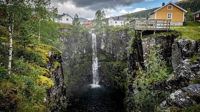
The trail from the Frafjord trailhead to Månafossen is a moderate out-and-back hike, roughly two to three hours round trip on uneven forest and rock terrain, ending at a viewpoint below a waterfall about 92 m high, the tallest in Rogaland.
Månafossen is the waterfall Rogaland hikers mention to each other rather than the one on the postcard rack. At around 92 m it is the tallest fall in the county, dropping over a rock face above the small farming valley of Frafjord in the Ryfylke area, and reaching it means an actual hike rather than a short paved walk from a car park. This guide covers the trail itself: how to get to the trailhead, what the path is like, how long to budget, and what tends to catch people out. For the full logistics of building a day around Frafjord from Stavanger, including transport options and how to pair the hike with other stops, see the dedicated day trip guide to Ryfylke and Månafossen.
Where Månafossen fits in Ryfylke
Frafjord sits inland from the main Ryfylke fjord network, reached by road rather than by the ferries that serve much of the region. The valley is narrow and green, with the waterfall visible from a distance well before the trail climbs close to it. Compared with the Lysefjord side of Ryfylke, where Preikestolen and Kjeragbolten draw the bulk of the region’s hikers, Frafjord and Månafossen stay markedly quieter. There is no fjellstue-style base camp, no ticketed shuttle system, and no crowd management on the trail — just a car park, a signed path, and a waterfall.
Månafossen at a glance
| Detail | Figure |
|---|---|
| Height | About 92 m — the tallest waterfall in Rogaland |
| Round-trip distance | Roughly 3.5-4 km |
| Round-trip time | About 2-3 hours |
| Difficulty | Moderate |
| Elevation gain | Around 250 m |
| Trailhead | Frafjord car park |
| Cost to hike | Free (parking may carry a small fee) |
| Nearest larger settlement | Jørpeland area, via Forsand |
Getting to the trailhead
The hike starts at a small car park in Frafjord, reached by road through the Ryfylke countryside rather than by boat. If you are driving yourself from Stavanger, the route runs out through Sandnes and Forsand before turning inland toward Frafjord — plan on close to an hour of driving each way before the hike even starts. There is no train or scheduled bus service that reaches the trailhead directly, which is the main reason most visitors without a car join a guided tour that includes transport, covered further down this page.
Parking at the trailhead is limited, and it fills on clear summer weekends. Arriving in the morning, rather than early afternoon, meaningfully improves your odds of a space and gives you a buffer if the trail is wetter or slower than expected.
The hike itself
From the car park, the path climbs steadily through birch forest, crossing a stream and passing over exposed rock sections as it gains height. The going is uneven throughout — roots, loose stone and the occasional muddy stretch after rain are normal, not an exception, so treat this as a real forest trail rather than a groomed park path. About halfway up, the waterfall comes into view across the valley, giving a sense of scale before you reach it.
The path ends at a viewpoint close to the top of Månafossen, where the water drops away below you toward the valley floor. There is no barrier at the edge, and rock near the falls is often wet from spray, so footing needs care in the final approach. Most hikers spend twenty to thirty minutes at the top before retracing the same route back down, which is also the way most parties choose to descend rather than attempting any alternative line.
Budget two to three hours for the full round trip at a comfortable pace, including time at the viewpoint. That is a fraction of the four to five hours typical for Preikestolen, which is one reason Månafossen works well as a shorter addition to a Ryfylke day rather than a destination requiring its own full day.
Difficulty, and how it compares to Preikestolen
It is worth being direct about this: Månafossen is not Preikestolen with a different name. Preikestolen’s trail is wide, heavily used, and built up with signage, a large trailhead complex and, in the order of 300,000 visitors a year, a genuinely crowded plateau in peak season. Månafossen’s path is narrower, less trafficked, and largely undeveloped beyond basic trail marking. That makes for a more solitary hike, but it also means less margin for error — fewer other hikers to help if something goes wrong, and less infrastructure generally.
The terrain itself is moderate rather than extreme: no chained sections like Kjeragbolten, no exposed scrambling, but genuinely uneven ground with real elevation gain. Reasonable fitness and proper footwear matter more here than technical hiking skill.
When to go
Late spring through early autumn is the realistic window for a comfortable hike, roughly May to September, when the trail is clear of snow and ice and daylight hours are long. Snowmelt in late spring can also mean the waterfall itself is at its most dramatic, though the trail may be muddier as a result. Outside that window, ice on the exposed rock sections and reduced daylight make the hike considerably harder to plan and less forgiving if conditions turn. For a closer look at how the falls and the trail change through the year, see the best season guide for Månafossen.
Rain is a near-constant possibility in Rogaland regardless of season, so checking a short-range forecast the morning of your hike is more useful than planning around a calendar month.
What to pack
- Hiking boots with real grip — trail runners are workable in dry conditions but risky on wet rock near the falls
- A waterproof and windproof shell, given how often spray or rain factors into the hike
- Layers, since temperature drops noticeably in the forest shade and near the water
- Enough food and water for two to three hours, since there are no facilities on the trail itself
- A phone with an offline map or the trail downloaded in advance, given patchy signal in the valley
For a fuller regional packing list covering the range of conditions you might meet across Ryfylke, see what to pack for hiking in Rogaland.
Guided options and tours
Because the trailhead sits well outside Stavanger with no public transport link, a guided option is the simplest way to reach Månafossen without a rental car. A few different formats cover the hike itself and nearby activities in Frafjord.
For hikers who want to add a physical challenge to the day, a combined trip pairs the Månafossen trail with via ferrata climbing and bouldering nearby, aimed at people who already want more than a straightforward walk.
If transport is the main obstacle, a guided tour with transport from Stavanger handles the drive out to Frafjord and back, removing the need to rent a car or work out the route yourself.
Some visitors prefer to make an afternoon of it: one option combines the hike with a traditional Norwegian meal afterward, a practical way to warm up and refuel after a few hours on the trail.
Travellers building a fuller Ryfylke day can look at a guided tour that links Månafossen with the Dalsnuten hike in the same outing, useful if you want two shorter hikes rather than committing a full day to just one.
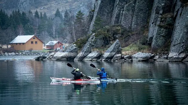
And for a different way to see the valley, a paddling-plus-hiking format gets you onto the water below Frafjord before the walk up toward the falls.
Nearby side trips
Frafjord’s location inland from the main Lysefjord corridor makes it a reasonable stop to combine with other Ryfylke stops rather than a full destination on its own. Dalsnuten, a shorter and easier hike closer to Sandnes, is a common pairing for visitors who want two walks in one day without either being especially long.
Drivers continuing further into Ryfylke often build the day around the wider four-day car itinerary through Ryfylke, which gives Månafossen room alongside stops like Gloppedalsura and Byrkjedal. For visitors without their own car, the question of whether a rental is worth it at all for this side of the region is covered in do you need a car in Stavanger.
Hikers looking for something gentler on the same trip might compare Månafossen against the region’s other short walks in best easy hikes near Stavanger, which sets it against options closer to the city itself.
Questions about hiking to Månafossen
How long does the Månafossen hike take?
Most hikers cover the round trip in two to three hours, including time at the viewpoint. It is far shorter than Preikestolen or Kjeragbolten, which makes it a realistic half-day outing rather than a full-day commitment.
Is the trail suitable for children?
Older children who are comfortable on uneven, sometimes wet forest paths generally manage it fine. There are sections with roots, rock steps and drops close to the path near the top, so this is not a stroller-friendly or toddler-friendly route.
Is Månafossen as busy as Preikestolen?
No. Preikestolen sees on the order of 300,000 visitors a year with a wide, heavily managed trail. Månafossen is a quieter, more low-key site near Frafjord with a narrower path, far fewer people, and none of the crowd infrastructure built up around Pulpit Rock.
Do I need to book anything in advance?
No ticket or permit is required to hike to Månafossen on your own. Parking at the Frafjord trailhead is limited, so arriving early on weekends and in peak summer months helps, especially if you are self-driving rather than joining a guided tour.
Can I combine Månafossen with another activity in Frafjord?
Yes. Frafjord also offers guided kayaking and stand-up paddleboarding on the fjord below, and some tours pair the Månafossen trail with a visit to Dalsnuten or a via ferrata and bouldering session in the same area.
Is the top of the waterfall safe to approach?
Treat the upper viewpoint with caution. Rock near the edge can be wet and slippery from spray, there is no barrier, and the drop is severe. Stay on the marked path and keep well back from the edge, particularly with children.
What should I wear for the Månafossen hike?
Solid hiking boots with grip, layered clothing and a waterproof shell are the minimum, since spray near the falls and Rogaland’s frequent rain can make rock surfaces slick even in summer.
Waterfalls on GetYourGuide
Verified deep-linked GetYourGuide tours. Book through these links and we earn a small commission at no cost to you.
GetYourGuide does not provide a product photo for this activity — the image shows the meeting point, photographed by us.