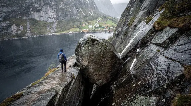
Himakånå Hike Guide: Haugesund's Answer to Trolltunga
Is Himakånå the same as Trolltunga?
No. Himakånå is a rock ledge near Haugesund and Karmøy nicknamed the 'Trolltunga of Haugesund' because of its similar shape, but the real Trolltunga is a separate, far more famous formation near Odda, well outside the Stavanger and Rogaland region this site covers.
A rock ledge with a borrowed name
Say “Trolltunga” to most people who have looked into a Norway trip and they picture one specific photograph: a thin tongue of rock jutting out over a valley near Odda, hundreds of hikers queuing for their turn to stand on the edge. That Trolltunga is real, it is famous, and it is not anywhere near Haugesund or Karmøy. Himakånå is a different rock formation entirely, tucked into the hills behind Haugesund, and the nickname “the Trolltunga of Haugesund” describes a resemblance, not a relocation. This page treats that distinction as the whole point, because getting it wrong is the single easiest way to plan a disappointing day.
If your trip is centred on Stavanger and the Lysefjord, Himakånå sits well outside your usual radius. It belongs to a northern extension of this guide’s coverage, the Haugesund and Karmøy area, reached separately from the Preikestolen and Kjeragbolten side of the region. Treat it as a deliberate detour for people who have already done the headline hikes, or who are building a longer Rogaland trip and want a hike that most visitors to Stavanger never hear about.
Why the nickname exists, and why it can mislead
The comparison to Trolltunga comes down to shape. Himakånå is a rock outcrop that projects outward with a similarly flat, tongue-like profile, set above a steep drop into the surrounding landscape near the coast. Photographed from the right angle, at the right time of day, a picture of someone standing on Himakånå can look strikingly like the famous Trolltunga shot — which is exactly how the nickname took hold locally and then spread online.
The trouble starts when that resemblance gets read as equivalence. The real Trolltunga is a specific, named, extensively documented hike near Odda, in Norway’s fjord country well to the north of the area this site covers, with its own trailhead, its own permit and shuttle arrangements, and its own reputation for six-to-ten-hour round trips and serious crowding in peak season.
Himakånå has none of that infrastructure, none of that name recognition outside Norway, and a completely different access route through Haugesund. If a search result, a translated blog post, or a fellow traveller conflates the two, you can end up looking for the wrong trailhead in the wrong part of the country. Read “Trolltunga of Haugesund” the way you would read “the Venice of the North” applied to some other canal city: a comparison worth taking seriously, not a claim that the two places are interchangeable.
Where Himakånå actually sits
Himakånå belongs to the Haugesund and Karmøy area, north of Stavanger along the coast, rather than to the Lysefjord hiking cluster that dominates most Rogaland itineraries. That geography matters for planning. Visitors doing a Stavanger-based trip built around Preikestolen and Kjeragbolten typically do not pass anywhere near Haugesund unless they add it deliberately, whereas visitors basing themselves in or routing through Haugesund can treat Himakånå as a natural half-day or full-day add-on alongside the area’s other attractions, including the Viking-age sites at Avaldsnes.
Because Himakånå does not have the crowd-management infrastructure of a Preikestolen — no ticketed shuttle system, no purpose-built trailhead car park with the same scale of paid parking, no steady stream of fellow hikers to follow when the path gets vague — most people find it considerably easier to arrange access as part of an organised trip. A guided hiking outing gets you the trailhead knowledge and the route-finding that a first-time visitor to this specific corner of Rogaland is unlikely to have. If you would rather have someone else handle logistics and pacing, a Himakånå guided hiking trip from Haugesund covers exactly that gap.
What the hike itself involves
Expect a proper hill walk, not a warm-up trail. The climb up to Himakånå gains height steadily over a route that is noticeably less worn and less consistently marked than the big-name Lysefjord hikes, which means normal hiking judgment — reading the terrain, watching the weather, knowing when to turn back — matters more here than it does on a trail with a steady stream of other hikers to follow. Underfoot conditions shift from established path to rougher ground as you climb, and the upper stretch, where the ledge itself comes into view, includes exposed sections above real drops.
None of that is a reason to avoid Himakånå if you already hike regularly. It is a reason to prepare properly: solid boots with ankle support, a layered system for wind and sudden rain (standard for anywhere in this part of Norway — see the climate notes on the main Stavanger page for how quickly conditions change even in summer), more food and water than you think you will need, and a realistic sense of your own turnaround time.
Given how much quieter this trail is than Preikestolen, do not count on passing hikers if something goes wrong; tell someone your plan and expected return time before you set out, and check current local trail conditions before committing, since neither signage nor rescue response here matches the resourcing of the flagship hikes further south.
Photographers who want the classic ledge shot should budget real time at the top rather than rushing it — the composition that makes Himakånå resemble Trolltunga only works with careful framing and, ideally, calm weather, since wind at height on an exposed ledge is not the moment to be experimenting with a tripod.
Season and weather
Rogaland’s coastal weather applies here just as it does around Stavanger: a wet climate overall, mild by the standards of Norway’s latitude but changeable at short notice, and considerably harsher at elevation than it looks from town. The realistic hiking window for Himakånå runs through the milder months of the year, broadly spring through early autumn, when daylight is long and the exposed upper sections are free of ice.
Outside that window, snow and ice on the steeper ground raise the difficulty and the risk sharply, and the lack of a maintained winter route means this is not a hike to attempt casually in the colder months — unlike, say, a sheltered coastal walk or an indoor-adjacent activity in Haugesund town, which stay viable year-round.
Even in the hiking season, check the forecast the morning you go rather than the forecast from a few days out. Coastal weather here can turn faster than inland forecasts suggest, and an exposed rock ledge is a poor place to be caught by a sudden squall.
Getting there from Haugesund
Haugesund is the practical base for a Himakånå day. If you are not driving yourself, or would simply rather not navigate an unfamiliar rural road network to find a trailhead with limited signage, a few options bridge the gap between Haugesund town and the surrounding hiking country. A guided scenic minibus tour around Haugesund is a reasonable way to see the wider area on a day when you are not committing to the full hike, and it gives a useful sense of the terrain before or after tackling Himakånå itself on a separate day.
For visitors without a rental car, the guided hiking trip remains the most dependable route to the actual trailhead, since public transport in this part of Rogaland is not built around hikers reaching a remote rural start point. If your itinerary already has you in Haugesund for other reasons — a stopover between Stavanger and Bergen, for instance — building a full day around the hike, arriving with transport arranged in advance, avoids losing half the day just working out logistics on the ground.
Making a full day of the Haugesund and Karmøy area
Himakånå rarely justifies a special trip on its own unless hiking is the main point of your visit to Norway. Most people get more out of the Haugesund and Karmøy area by pairing the hike with something gentler. The Viking-age settlement at Avaldsnes, on Karmøy, sits close enough to combine with a Himakånå day, and unlike the hike itself asks nothing of your legs beyond a level walk between historical sites — see the dedicated Avaldsnes Viking farm guide for what that visit actually covers.
On the water, a RIB safari out to the island communities around Haugesund shows a side of the region that a hilltop hike cannot: the scattered islands and channels that define this stretch of coast, seen at speed from a rigid inflatable boat rather than from a summit. It pairs naturally with a hiking day as the lower-effort half, whether you do it the same afternoon or on the day either side.
Travellers who prefer wheels to boots can cover a comparable amount of ground with a guided electric boat tour or an e-bike loop through Haugesund town, both considerably less demanding than the Himakånå trail and better suited to a rest day bracketing a harder hike. For a broader half-day introduction to the area before deciding how much hiking to add, the Highlights of the Region Half Day Tour style outings from Haugesund cover the main sights without requiring the fitness the Himakånå trail does.
Himakånå against the region’s other big hikes
It is worth being explicit about how Himakånå compares to the hikes most visitors already have on their radar, since the “Trolltunga of Haugesund” tag invites exactly that comparison.
| Trail | Region | Rough shape of the hike | Crowd level |
|---|---|---|---|
| Himakånå | Haugesund / Karmøy | Long, steep, exposed near the top, limited signage | Low — a genuinely quiet trail |
| Preikestolen | Lysefjord | Long but well-marked, heavy foot traffic | Very high, around 300,000 visitors a year |
| Kjeragbolten | Lysefjord | Longer, chained sections, seasonal road access | Moderate, self-selecting for experienced hikers |
| Dalsnuten | Near Sandnes | Short, accessible, good views for modest effort | Moderate, popular with locals |
Read side by side, Himakånå occupies a niche none of the others quite fill: as demanding as the harder Lysefjord hikes in places, but without their crowds, their signage, or, frankly, their name recognition outside Norway. For a broader sense of how the two main Lysefjord hikes stack up against each other before you decide how Himakånå fits into a longer trip, see the Kjeragbolten versus Preikestolen comparison.
If Himakånå sounds like more than you want to take on, Dalsnuten near Sandnes delivers a rewarding view for a fraction of the effort, and the roundup of easy hikes near Stavanger covers several more options at that gentler end of the scale.
Practical checklist before you go
A short list is more useful here than a long one, precisely because Himakånå does not come with the built-in guardrails of a heavily visited trail.
- Confirm the current trailhead access and any parking arrangements before driving out — do not assume the same level of signage as Preikestolen.
- Check the forecast the morning of the hike, not days in advance; coastal weather here shifts quickly.
- Wear real hiking boots and bring layers for wind and rain regardless of the season.
- Tell someone your planned route and expected return time, given how little passing foot traffic there is to rely on.
- If in doubt about navigation or fitness for the terrain, book a guided hike rather than going in blind.
- Plan the hike for the milder months; treat winter conditions here as a reason to choose a lower-elevation activity instead.
- Do not plan the day assuming this is the famous Trolltunga near Odda — it is a separate hike, a separate region, and a separate trip.
Building it into a longer Rogaland trip
If Haugesund and Karmøy are a detour from a Stavanger-based stay rather than your main base, it is worth deciding in advance how much time the area deserves. A single overnight lets you fit the Himakånå hike, a visit to Avaldsnes, and one lower-effort activity such as the RIB safari or the e-bike loop without rushing any of them.
Travellers assembling a full Rogaland route who have not yet worked out how many days the whole region needs can start from the general planning notes on how many days you need in Stavanger and the day trip guide to Haugesund and Karmøy, then decide whether Himakånå’s steeper demands fit that schedule or push the area onto a separate visit.
Drivers linking the two areas by road should also check whether you actually need a car in Stavanger, since the calculus changes once Haugesund enters the itinerary. For a structured multi-day frame that already accounts for a Haugesund detour, the Haugesund and Karmøy weekend itinerary is built around exactly this pairing of the hike with the area’s gentler sights.
Himakånå, honestly
Himakånå earns its nickname on looks alone, and on a clear day, standing on that ledge above the Haugesund countryside is a genuine highlight for anyone who makes the effort to get there. What it is not, and what no visitor should arrive expecting, is a substitute for the real Trolltunga near Odda, a shortcut version of Preikestolen, or a casual add-on for a day already built around something else. Go in treating it as its own hike, in its own part of Rogaland, and it delivers exactly what a quiet, demanding trail with a borrowed name ought to: a good story, a good view, and none of the queue.
tours.hiking-trails
Verified deep-linked GetYourGuide tours. Book through these links and we earn a small commission at no cost to you.
GetYourGuide does not provide a product photo for this activity — the image shows the meeting point, photographed by us.