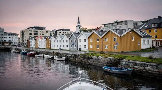
An Island Bigger Than Its Most Famous Site
Most people who come north from Stavanger to Karmøy are chasing one thing: Avaldsnes, the old royal seat where Norwegian kings are said to have gathered tribute from passing ships. It’s a fair reason to come. But Avaldsnes sits on the eastern side of an island that runs roughly 30 km north to south, with its own network of villages, farmland, wind-scoured headlands and one genuinely excellent small town — Skudeneshavn — that most Avaldsnes day-trippers never reach.
That’s the trap worth naming up front. Karmøy is not a single attraction with a car park; it’s a whole island, part of the wider Haugalandet region alongside Haugesund on the mainland. This page covers the island beyond Avaldsnes: how to get there, what Skudeneshavn actually looks like, the coastal drive between the two, and where Karmøy fits if you’re building a longer loop north of Stavanger. If you’re specifically after the viewpoint on the island’s western cliffs, that’s covered separately too — see the dedicated Himåkånå guide rather than expecting it folded in here.
Getting to Karmøy from Stavanger
Karmøy connects to the mainland by a fixed bridge near Haugesund, so a car trip from Stavanger is a straightforward, if not short, drive: figure on 1 to 1.5 hours each way via the E39 north through Haugesund, depending on traffic and exactly where on the island you’re headed.
Kolumbus, the regional transport operator, runs buses between Stavanger and Haugesund with onward local connections into Karmøy’s towns, though frequency thins out once you’re off the main routes — this is a region where a car (your own, rented, or a tour minibus) genuinely changes what’s realistic in a day. For the wider question of whether you need one at all for this trip, the do you need a car in Stavanger guide lays out the trade-offs.
Karmøy is also reachable by ferry links further up the coast for anyone routing onward toward Bergen, but for a Stavanger-based visit, the bridge route via Haugesund is the one that makes sense for almost everyone.
Skudeneshavn: A Wooden Town Built on Herring
If Gamle Stavanger’s cluster of white wooden houses is the image most visitors carry away from the city, Skudeneshavn, at Karmøy’s southern tip, is its quieter cousin — and arguably its equal. The town grew wealthy in the 19th century on the herring trade, when the fjords off western Norway filled with shoals large enough to support entire fleets and the merchants who serviced them. That money went into building: narrow streets of white-painted wooden houses, a harbour lined with warehouses converted for later uses, and a scale that has stayed small because the herring, eventually, moved on and the town never industrialised over its own core.
The result today is a protected townscape you can walk in an hour or linger in for half a day, without the volume of visitors that Gamle Stavanger sees on a cruise-ship afternoon. There’s no single monument to tick off in Skudeneshavn — the point is the whole, the way the houses sit against the harbour and the streets narrow toward the water. Coffee, a walk along the quay, and no fixed itinerary is roughly the right approach.
The Coast in Between: Villages, Farmland and Wind
The drive or ride between Avaldsnes in the north and Skudeneshavn in the south covers the part of Karmøy that almost nobody photographs, which is exactly why it’s worth a slower pass if you have the time. Expect open farmland, low stone walls, small fishing harbours, and — on the island’s more exposed western edge — some of the wind conditions that have made Karmøy relevant to Norway’s renewable energy industry as well as its historic sailors. It’s not a dramatic landscape in the way the Lysefjord is dramatic; it’s a working island, and that’s part of the point of including it in a trip that otherwise leans heavily on fjord cliffs and waterfalls.
Villages worth a stop if you’re driving rather than touring on a fixed schedule include the smaller harbours south of Avaldsnes, where you’ll find a fraction of the visitors and none of the infrastructure built around the Viking site. This is where a self-driven day earns its cost over a fixed bus tour: you can stop where the road looks interesting rather than where a schedule says to.
Karmsundet: The Strait Behind the Name
Between Karmøy and the mainland runs Karmsundet, a narrow, sheltered strait that shipping used for centuries before sailors trusted the open sea along this stretch of coast. Some historians link Norway’s own name to journeys through protected passages like this one — sailing “the way north” through calm inside water rather than around the exposed outer coast.
Whether or not that etymology is the full story, Karmsundet’s usefulness as a shipping lane is a large part of why this stretch of coast, Avaldsnes included, mattered enough to be worth ruling over in the Viking Age. For the fuller version of that history — the royal seat itself, the church, the “Virgin Mary’s Synne” stone — see the dedicated Avaldsnes guide rather than expecting it repeated here.
The same historical thread connects to Sverd i Fjell, the three giant swords planted at Hafrsfjord near Stavanger to mark the battle traditionally credited with unifying Norway. Karmøy, Avaldsnes and Hafrsfjord form a loose historical triangle around Stavanger, and travelers building a Viking-themed day sometimes combine them — the swords in rock guide and the blog piece on what that unification myth actually rests on are useful context either before or after a Karmøy day.
Seeing the Island Communities from the Water
Karmøy’s coastline and the scatter of smaller island communities around it are arguably better appreciated from a boat than a car window, since much of what makes this stretch of coast distinctive — the channels, the small harbours, the way settlements sit right at the waterline — doesn’t read the same way from a road above it.
A RIB safari out of Haugesund that tours the island communities around Karmøy covers that ground quickly and gives a different sense of scale than driving between the same points. For a calmer pace with a guide narrating the history and geography as you go, an electric boat tour with a guide departing from Haugesund is the gentler alternative — no wetsuit, no speed, just a quiet pass along the coast.
Neither of these is a Karmøy-specific product built solely around Skudeneshavn or the coastal villages described above, so treat them as a complement to a self-driven day rather than a replacement for actually walking Skudeneshavn’s streets — the boat shows you the shoreline, not the town.
Combining Karmøy with Haugesund
Because Karmøy sits directly across the bridge from Haugesund, almost nobody visits the island in isolation. The two are usually paired into a single day trip from Stavanger, with Haugesund covering city sights, food and the mainland side of the Haugalandet region, and Karmøy providing Avaldsnes, Skudeneshavn and the coastal drive. The day trip to Haugesund and Karmøy guide walks through a realistic order for combining the two without over-scheduling the day, and the Haugesund and Karmøy weekend itinerary stretches the same combination across two days for anyone who’d rather not rush Skudeneshavn.
If Viking history is the organising theme of your trip rather than a single detour, the Viking Rogaland itinerary threads Karmøy in alongside other sites across the wider region, and the things to do in Haugesund and Viking history category pages are worth a look for filling out a day with more than the two headline stops.
Weather and When to Go
Karmøy sits fully exposed to the North Sea, more so than Stavanger itself, which means wind is a bigger factor here than rain — bring a windproof layer even on a sunny day. May to September is the comfortable window for walking Skudeneshavn’s streets and driving the coast at leisure; outside that range, the island is still accessible but the appeal of lingering outdoors drops considerably, and a fast Avaldsnes-only visit becomes the more realistic plan.
Practicalities
A day covering Avaldsnes, Skudeneshavn and the coast in between, plus a meal, typically runs to something like the table below for planning purposes — actual costs vary with how much time you spend eating out versus packing food, and whether you’re driving yourself or joining an organised tour.
| Item | Approximate cost (NOK) |
|---|---|
| Fuel or return bus fare, Stavanger–Karmøy | 200-400 |
| Lunch in Skudeneshavn or Haugesund | 150-300 |
| Coffee, snacks | 50-100 |
| Optional boat tour around the island communities | 800-1,500 |
Card payment is standard everywhere on Karmøy, as across the rest of Norway, so there’s no need to plan around cash. And as with the rest of a Rogaland trip, it’s worth remembering that Norway isn’t in the eurozone — prices here are in Norwegian kroner, not euros, and budgeting in the wrong currency is an easy way to underestimate a day’s cost.
Karmøy and Skudeneshavn: Common Questions
Is Karmøy the same as Avaldsnes?
No. Avaldsnes is one historic site on Karmøy, a large island with dozens of villages, farmland and a long coastline. Treating a visit to Avaldsnes as a visit to the whole island means missing most of it, including Skudeneshavn.
How do you get from Stavanger to Karmøy?
By car, the route runs north through Haugesund and across the Karmsund bridge, around 1 to 1.5 hours depending on traffic. Kolumbus buses connect Stavanger and Haugesund, with local connections onward to Karmøy’s towns.
Is Skudeneshavn worth visiting?
Yes, especially for anyone who liked Gamle Stavanger. Skudeneshavn is one of Norway’s best-preserved wooden towns, built on the 19th-century herring trade, with a harbour and streets that reward slow walking rather than a checklist visit.
Can you visit Karmøy without a car?
It is possible using Kolumbus buses via Haugesund, but the island’s villages and coastal roads are spread out, and a car or an organised tour makes a single day cover far more ground.
How much time do you need on Karmøy?
Avaldsnes alone can be done in an hour or two. Adding Skudeneshavn and a drive along the coast turns Karmøy into a comfortable half-day trip, or a full day paired with Haugesund.
What is Karmsundet and why does it matter historically?
Karmsundet is the strait between Karmøy and the mainland, a sheltered shipping lane used for centuries before open-sea sailing was reliable. Some historians connect Norway’s name to sailing “the way north” through waters like this one.
Is Karmøy touristy like Preikestolen?
No. Karmøy sees a fraction of the visitors that the Lysefjord hikes do. Outside Avaldsnes itself, most of the island — including Skudeneshavn — stays quiet even in the summer season.