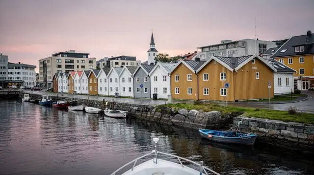
The Dalane Coast: Egersund, Flekkefjord and Jøssingfjord
What is the Dalane coast and how is it different from Jæren?
Dalane is the southernmost stretch of Rogaland, built around Egersund, Flekkefjord and the Jøssingfjord Magma Geopark. It lies well south of the Jæren beaches and their lighthouses at Kvassheim and Obrestad, with a rockier, fjord-cut coastline and a fraction of the visitor numbers.
A southern coast, not a Jæren extension
Most Stavanger itineraries stop at Jæren: the long sandy beaches around Orre and Solastranden, the lighthouse walks at Kvassheim and Obrestad, all within an easy half-day of the city. Keep driving south past Bryne, though, and the coastline changes character completely. This is Dalane, Rogaland’s southernmost district, built around the towns of Egersund and Flekkefjord and the dramatic cut of Jøssingfjord with its Magma Geopark.
It is worth being precise about this distinction, because guidebooks and search results often blur the two. Jæren is flat, open and sandy — a genuine exception on a fjord coast. Dalane, by contrast, is rocky, fjord-indented and hillier, closer in feel to the fjord country further north than to the beaches of Jæren. The two regions sit on the same coastal road south of Stavanger, but they are not the same place, and they reward different kinds of visits. If you came here for lighthouse walks on open sand, that guide is the one on Kvassheim and Obrestad, not this one.
What Dalane offers instead is quieter towns, genuine maritime history and a UNESCO-listed geological landscape that sees a fraction of the visitors Preikestolen or even Jæren get in a season. That relative obscurity is the main reason to come.
Egersund: the old fishing and pottery town
Egersund sits at the mouth of a sheltered natural harbour about an hour’s drive south of Stavanger, and for most of its history that harbour was the point of the place. It grew wealthy first from herring fishing, then from a 19th-century pottery industry — fayance, tin-glazed earthenware — that put the town’s name on plates and bowls across Scandinavia. The old town centre around the harbour still has a dense cluster of white wooden houses on narrow streets, smaller and less visited than Gamle Stavanger but built from the same tradition of coastal timber architecture.
The pottery history is still visible and, unusually for a small Norwegian town, still explorable in some depth. The old Egersund Fayancefabrik building now houses a museum collection covering the factory’s output from the 1840s onward, and it is a reasonable stop if you want more than a walk around the harbour.
a timed entrance ticket to the Egersund pottery museum covers the collection without needing to check opening hours on arrival, which matters here more than in Stavanger — this is a small-town museum with a limited schedule, not a year-round city attraction with flexible hours.
Outside the pottery history, Egersund’s harbour is still a working fishing port, and the church — a large wooden cruciform building from the 1620s — is one of the largest wooden churches in Norway, worth a look if it happens to be open. There is no need to build a whole day around Egersund on its own; an hour or two on the way to or from Flekkefjord is enough for most visitors.
Flekkefjord and Hollenderbyen
Flekkefjord is smaller again than Egersund, and it is built around a genuinely distinctive quarter: Hollenderbyen, the “Dutch town.” The name comes from the 17th and 18th centuries, when Flekkefjord grew rich trading fish, timber and other goods with Dutch merchants, and the wealth shows in a tight grid of narrow lanes lined with white and pastel wooden houses, closer together and more town-like than the more spread-out Gamle Stavanger.
Hollenderbyen rewards slow walking rather than a checklist of sights: there is no single must-see building, but the density and consistency of the old streets is the point. A Dutch-influenced house from the trading era, a small local museum, a handful of cafés — it is a pleasant hour or two rather than a half-day attraction, and that scale is part of its appeal after busier stops elsewhere in Rogaland.
The harbour itself is still active with fishing boats, and Flekkefjord’s setting — tucked into a narrow inlet with hills rising steeply on both sides — gives a preview of the more dramatic fjord scenery at Jøssingfjord just to the west. For a different, working angle on that same coastal fishing tradition, a hands-on fishing trip out of Flekkefjord’s harbour puts you on the water with people who still do this for a living, rather than only viewing the boats from the quay.
Jøssingfjord and the Magma Geopark
West of Flekkefjord, the road drops into Jøssingfjord, a narrow, steep-sided inlet that looks dramatic even before you know its geological significance. This stretch of coast sits inside the Magma Geopark, a UNESCO-recognised area protecting one of the largest and oldest exposed formations of anorthosite and pyroxenite rock in the world — bedrock roughly a billion years old, laid bare by later ice-age erosion.
The geopark is not a single fenced site but a loose network of marked trails, viewpoints and small exhibits spread across the Jøssingfjord area, including old ilmenite mining remains that once extracted titanium ore from this same rock. Compared to Preikestolen or Kjeragbolten, the trails here are short, unmarked by crowds, and aimed more at people interested in geology, industrial history or a quiet coastal walk than at anyone chasing a single dramatic viewpoint. There is no equivalent here to the queues on the Lysefjord side of Rogaland — that is effectively the whole appeal.
Jøssingfjord also carries a specific piece of Second World War history: it was the site of the 1940 Altmark incident, when a British destroyer intercepted a German supply ship inside Norwegian waters, an episode often cited as one of the sparks for the German invasion of Norway weeks later. A small memorial and information panels mark the spot.
| Area | Character | Typical time needed |
|---|---|---|
| Egersund | Old harbour town, pottery museum | 1-2 hours |
| Flekkefjord / Hollenderbyen | Dense old wooden quarter, walking | 1-2 hours |
| Jøssingfjord Magma Geopark | Geology, short trails, WWII history | 1-3 hours |
| Sirdal (inland) | Mountains, lakes, further detour | Half day+ |
How Dalane compares to Jæren and Lysefjord
It helps to place Dalane against the two other coastal areas most visitors already have in mind before arriving in Rogaland.
| Jæren | Lysefjord area | Dalane | |
|---|---|---|---|
| Landscape | Flat sandy beaches | Deep fjord, steep cliffs | Fjords, rocky coast, old towns |
| Signature sights | Kvassheim, Obrestad lighthouses | Preikestolen, Kjeragbolten | Hollenderbyen, Magma Geopark |
| Distance from Stavanger | 20-40 minutes | 25-90 minutes | 1-1.5 hours+ |
| Crowd levels | Moderate, seasonal | High, especially Preikestolen | Low |
| Best suited to | Beach walks, cycling | Hiking, fjord views | Slow towns, geology, quiet coast |
The practical conclusion is straightforward: if your Rogaland itinerary already includes a day at Jæren’s beaches and its lighthouse walk, Dalane is not a substitute for that day — it is an additional, separate excursion further south, best treated as its own trip rather than folded into a Jæren itinerary. The region has its own dedicated south-coast itinerary for travellers who want to build a day or two specifically around Egersund and Flekkefjord, distinct from anything built around Jæren’s beach coast.
Getting there and getting around
Dalane’s towns sit along the E39 south of Stavanger, and a car is the practical way to see more than one of them in a day. Egersund is about an hour’s drive from central Stavanger; Flekkefjord adds another 45 minutes to an hour past Egersund, and Jøssingfjord is a short detour off the road between Flekkefjord and Sirdal, the mountainous inland area further east that some visitors combine with a Dalane day for a mix of coast and higher terrain.
Regional buses connect Stavanger, Egersund and Flekkefjord, but frequency drops noticeably compared to routes closer to the city, and the geopark trails around Jøssingfjord and the inland stretches toward Sirdal are difficult without a car. If you are already weighing whether you need a car for the rest of your Rogaland trip, the same car-versus-no-car reasoning that applies around Stavanger applies here with even less flexibility on the no-car side.
For planning the route itself, the site’s interactive map plots Dalane alongside the more familiar Jæren and Lysefjord stops, which makes the geographic separation between them easier to see than any written description.
Practical notes
Dalane is a low-key add-on rather than a headline destination, and it is worth setting expectations accordingly. There are no paid entry fees to the geopark trails themselves, though the pottery museum in Egersund charges admission. Fuel and food prices follow the same pattern as the rest of Norway — Dalane is not cheaper than Stavanger, and prices are quoted in Norwegian kroner rather than euros, a point covered in more general terms in this site’s note on Norway sitting outside the eurozone.
Weather along this stretch of coast follows the same wet, changeable pattern as the rest of Rogaland, if anything slightly more exposed to Atlantic wind and rain given the open coastline around Jøssingfjord. Layered, waterproof clothing is worth packing regardless of season, and the geopark trails can be slick after rain even though none of them involve serious elevation gain.
Because Dalane is a lower-traffic region than Jæren or the Lysefjord side of Rogaland, it is also a reasonable place to recalibrate expectations about the region generally — a theme this site returns to in its broader look at what Stavanger and its surroundings are not. Dalane will not deliver a single iconic photograph the way Preikestolen does.
What it offers instead is a working, lived-in stretch of coast that most visitors to Stavanger never see, and that is worth valuing on its own terms rather than measuring against the region’s more famous sights. For a category-level view of coastal and lighthouse content across the whole site, the lighthouses and coast section sits alongside the Jæren lighthouse walks without collapsing the two regions into one.
Frequently asked questions about the Dalane coast
Is the Dalane coast part of Jæren?
No. Jæren is the flat, sandy stretch of coast southwest of Stavanger around Orre and Borestranden. Dalane starts further south, past Bryne, and is a separate, more rugged region built around Egersund and Flekkefjord.
How far is Egersund from Stavanger?
Egersund is roughly an hour’s drive south of Stavanger, and Flekkefjord adds another 45 minutes to an hour beyond that, so a return day trip covering both is a full day on the road.
What is the Magma Geopark at Jøssingfjord?
It is a UNESCO-listed geopark protecting an ancient anorthosite and pyroxenite landscape around Jøssingfjord, one of the oldest exposed rock formations in Europe, with marked trails and small museums explaining the geology and mining history.
Are there lighthouses on the Dalane coast like at Jæren?
The Dalane coast is defined more by fjords, harbours and old fishing villages than by open lighthouse headlands. The dedicated lighthouse walks at Kvassheim and Obrestad belong to Jæren, further north, not to Dalane.
Can you visit Dalane without a car?
It is possible by regional bus between Stavanger, Egersund and Flekkefjord, but services are infrequent and the smaller sights around Jøssingfjord and Sirdal are hard to reach without a car.
What is Flekkefjord’s Hollenderbyen?
Hollenderbyen, the Dutch town, is Flekkefjord’s old wooden-house quarter, built on wealth from 17th and 18th century trade with the Netherlands, with narrow lanes and white clapboard houses around the harbour.
Is a day enough for Egersund and Flekkefjord?
A single long day covers both towns and a stop at Jøssingfjord, but it is a full, driving-heavy day. Splitting it over two days, or overnighting in Flekkefjord, allows more time in the geopark and Hollenderbyen.
tours.lighthouses-coast
Verified deep-linked GetYourGuide tours. Book through these links and we earn a small commission at no cost to you.
GetYourGuide does not provide a product photo for this activity — the image shows the meeting point, photographed by us.